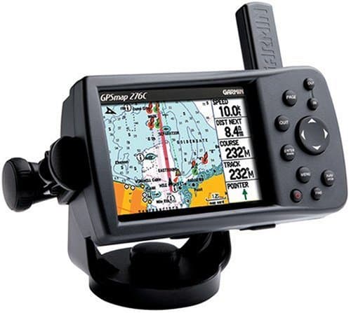
Garmin GPSMAP 276C
Clarity of Instructions
Ease of Use
Map Accuracy
Garmin GPSMAP 276C
When you purchase through links on our site, we may earn an affiliate commission. Here's how it works.

User Reviews
Value For Money
Ease of Use
Clarity of Instructions
Map Accuracy
This Is A Great Gps Plotter, However, You Might Ne
This is a great GPS plotter, HOWEVER, you might need to buy a new battery each season (for about 40 quid).
Value For Money
Ease of Use
Clarity of Instructions
Map Accuracy
The Garmin Gps276c Sat Nav Unit Is A Nice Evolutio
The Garmin GPS276C sat nav unit is a nice evolutionary step in GPS technology for the Marine user as well as a driver. If you would like to have a GPS receiver for automotive use and another for marine navigation, you can get both with the GPSmap 276C. You can switch modes easily and have separate setups for each. Set up the page layouts and parameters for your car trip: data fields, statute miles for distance, speed in MPH, page sequence, etc. Then switch to marine mode and set it up for different data fields, nautical miles, speed in knots, more pages, etc. When you switch back and forth the unit will retain the options you selected for each mode. Even the maps will switch from the road map to the marine map. It really is having two units in one.The GPSmap 276C is a 12 channel marine chartplotter/car navigator unit which includes WAAS capability (Wide Area Augmentation System). It is housed in a black case about 5 3/4 inches wide by 3 1/2 inches high. There is a removable mounting bracket included which increases the total width to about 6 1/2 inches. The unit has a 256 color TFT display that is very readable in direct sunlight. This is unlike the GPSmap 176C which practically loses its visibility in sunlight. The viewing screen is about 3 1/8 wide by 2 1/4 high (3 7/8 diagonal). The G276C supports the autorouting feature found in many Garmin MapSource products, and in automotive mode will create a route following the roads, rather than a series of straight lines. We were disappointed to find that the GPS-276C uses the older Garmin memory card. Though a 256 megabyte (maximum size) Garmin memory card is now available, these are considerably more expensive "per megabyte" than the CF memory card used in the new StreetPilot 2610 series.The packaged unit comes with a rechargeable Lithium battery, mounting bracket to fix the unit to a solid surface, data cable for programming from a computer USB port, a power and USB data cable to use with external power and other devices which can accept Garmin's USB data format (i.e. depth finder, water speed and temperature indicator, autopilot), a 110 volt power supply which powers the unit and charges the battery, and MapSource Trip & Waypoint Manager. (A serial port for NMEA-0183 output is available and requires an optional cable, not included with the package. List Price for the optional cable is US$38.09) Although listed as a marine unit, the GPSmap 276C is quite suitable for using in an automobile when programmed with the MapSource CityNavigator highway maps. With three swivel joints on the mounting bracket, the unit can be fixed to about any angled surface and still be adjusted for easy viewing. Also available is an automotive mounting bracket for using it in a car.The basemap, which is permanently installed, is Americas AutoRoute 1.00. It shows the countries and major cities around the world, and major highways in North, Central, and South America. It contains information about businesses, service stations, restaurants, lodging, marinas, and many other points of interest. If you load another map in the data card memory that doesn't support auto routing, the GPSmap 276C will still create a route following the roads of the basemap. Since this map doesn't have all the detail of some of the other maps, you may see some parts of the route that don't follow the roads of your data card maps.A cable included with the unit can be connected to a DC source of 11 to 35 volts DC for external power. If it loses external power, it will sound an alarm and display a message that it will shut down in 30 seconds. Pressing any key will switch it to internal battery power. If the external power is restored before the 30 second timeout, it will resume operating on the external power.The antenna is attached to the back of the unit and can be rotated down out of the way when not in use. It can be removed and an external antenna can be attached if it is desirable to have the unit located in such a place that it cannot receive data signals from the GPS satellites. While the unit's antenna is reasonably robust, care should be used in removing it to avoid damage. See the details on this later in this review.This particular unit has internal system software version 2.60, the latest available at the time of writing. Any future updates can be obtained from the Garmin web site at no charge and loaded into the device.
Q&A
There are no questions yet.